Project/Shared coordinates in Revit and the knot that slipped.
First some observations. And then
to untie the knot.
Unclipping project base point and lowering it -10’ makes
level 1 go to 10’. This Is -10’ from the site survey point.
If site point is left clipped and moved to the project point
the project point will return to 0’-0”
If we want to set the shared coord to be 100’-0” then
unpinning the site survey point and moving up to 100’. Reclipping and moving to
align with level 1 will set the shared coord at that point to be 100’
This will set the project base point to be 90’.
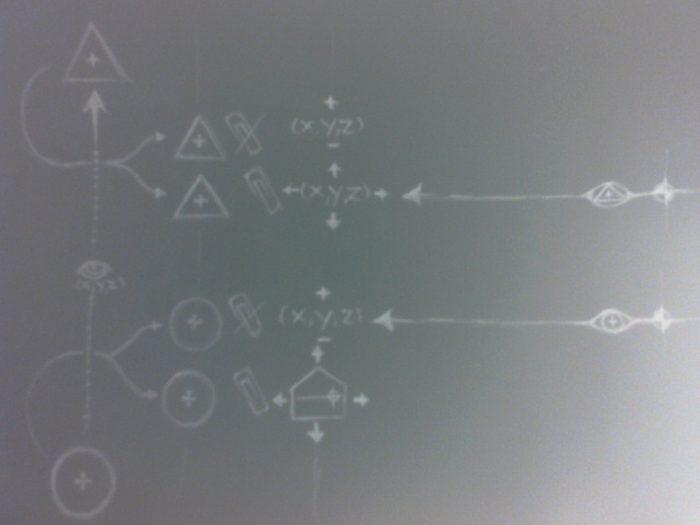
Observed:
Project base point
displays in relation to site survey point.
Levels set to project coord will display its distance from
the project base point. (not the actual elevation)
Levels set to site survey will display clipped relation to survey point.
Unclipping survey
point allows the changing of values of that point. Level will remain. Moving
the clipped survey point will change
the level readout as distance from survey point.
Moving unpinned project base point closer or further from
site point will change the value of the level reading the project cords. Moving
pinned project base point will pull project away from survey point changing
levels relating to shared cords.
Using specify cords at a point and selecting the level will
move the survey point if it is pinned to those coordinates in relation to the
project base point.
Using specify cords at a point and selecting the level with
the survey point unpinned will leave its relationship to the project base point
unchanged but will update any levels
showing survey cords and will change the project coord points value to relate
back to the survey point.
Acquiring coordinates and base points. Observed
Unclipped
Before:
After:
Physical point doesn’t move. Both survey and project cords(elevations
only) are updated with linked models
Clipped:
Survey point is moved(elevation) in order to create the
updated position of the project base point.
The KNOT I created
and how to untie it. Problems and solutions(hopefully)
So how best to solve this problem?
Structural started modeling first. Using a project base
point of 650’ and a shared of 0’-0” so that the plan spots reported correctly
to the engineers markups. We were
modeling from existing drawings that showed the civil elevations so that is how
we started the model.
structural
architectural
I think I could easily bring in the arch file. Move it to
line up and acquire coordinates, but this wouldn’t solve the problem of how our
project coordinates relate. Also the arch cords have already been acquired (my
bad)
This will require some moving of survey/project base points I
think? If someone out there has comments on my madness please …drop me an email
or post here.
Trial one: Project base point
Unpinning project base point to move up to -100’ which gives
level one in my structural file a project level of 100’
This worked
Trial two: survey base point
Unpinned and moved up to 650’. Pinned and moved back down to
align with level 1.
Now we can bring in the arch file “by shared coords” and our elevations will match theirs.
CANNOT bring in
origin to origin. I think it is because of Revit’s internal project
coordinates. It will still bring in architectural at 100’. Which is still below
550’ that we are
How to get the
Internal origins to align.(so you can use origin to origin again)
**p.s. you may
just be better off using shared coords and not be so crazy about origin to
origin like I am)
So the steps are:
Once the project and survey points match the file you are
trying to link in origin to origin.
Link it in. if it comes in at a different elevation. then:
-
Unclip the project base point, move it the
difference in its elevation and the linked file.
-
Select all of the levels move them in the same
direction the same amount. (this maintains their project elevation reported
from the distance of the project base point).
-
Move the CLIPPED survey point the same amount in
the same direction. (this updates the project elevation in relation to the
survey point).
Lesson
Learned.
It is probably best to NEVER model your project starting out
to the civil elevation (as your project base). It should be 0’-0” or 100’-0”. I
had to wait until the architect started modeling to learn this lesson. If you are confused modeling the existing
drawings start with the project at 0’-0” and set your shared coords to the
civil elevation (650’-0”) in the example above.
So this solved getting our model to line up origin to origin
with arch when we started modeling first and had it all fubar. So what happens
when civil is moving our models around on site and that site survey point isn’t
in the correct place…I will leave that knot for them to untie.
Time for a motorcycle ride to clear my head and then on to
Max and skin morphing or some Game of Thrones.
p.s i know most people are going to tell me quit being so crazy and just use Shared coordinates. but hey...my pain is your gain...i learned something, hope you did too.